
We almost did this trip on bikes.
For several weeks, that was the entire plan.
Death Road videos kept appearing in the group chat late at night. Somebody became obsessed with high-altitude bikepacking routes across the Altiplano. Another started pricing absurd titanium gear setups as if we were preparing for an unsupported polar expedition instead of a holiday with friends.
At first, the suffering itself sounded appealing.
Long rides through empty desert.
Physical exhaustion.
Tiny villages at impossible altitude.
The kind of trip people describe afterward with slightly haunted expressions and phrases like:
“Honestly… it changed me.”
But the deeper we researched Bolivia, the more obvious something became: the landscapes themselves were actually the main attraction, not the suffering.
Southwestern Bolivia is one of those rare places where covering distance genuinely matters because the scenery changes violently from one region to another: salt flats, red lagoons, volcanic deserts, steam vents, lava formations, black alpine lakes, and roads that seem to disappear directly into the horizon.
On bikes, we would have experienced Bolivia physically. In a 4x4, we realized we could experience far more of Bolivia itself.
The second thing that changed our minds was honesty.
At some point during planning, we finally admitted to ourselves that the fantasy version of “five friends crossing Bolivia on bikes” sounded slightly better than the probable reality: altitude sickness, mechanical failures, days destroyed by wind, and spending huge portions of the trip physically wrecked instead of actually absorbing where we were.
None of us wanted a polished luxury overland tour either.
That option disappeared quickly after looking at several international operator itineraries where everything felt over-curated: identical sunset photos, glamping tents, carefully staged picnic lunches, and schedules so controlled they almost removed the feeling of discovery entirely.
Bolivia did not feel like a country that should be over-managed.
Eventually we landed somewhere in the middle: two rented 4x4 vehicles, basic camping equipment, offline maps, local route advice, and enough flexibility for the trip to occasionally drift off-script.
That decision ended up shaping the entire tone of the experience.
The trip stopped feeling like “an endurance challenge” and became “five friends disappearing into one of the strangest landscapes on earth.”
Why We Chose the Slow Overland Route
One thing we realized very quickly while researching Bolivia is that most travelers only experience tiny fragments of the southwest.
Some do a single Death Road descent from La Paz. Others visit the Salar de Uyuni for one rushed photography day before leaving again.
But once we started looking deeper into the map, the slower six-day overland loops south of Uyuni became far more interesting, especially the routes pushing toward Laguna Colorada, the Salvador Dalí Desert, high-altitude geysers, remote desert tracks, and eventually Laguna Negra far away from the main tourist circuit.
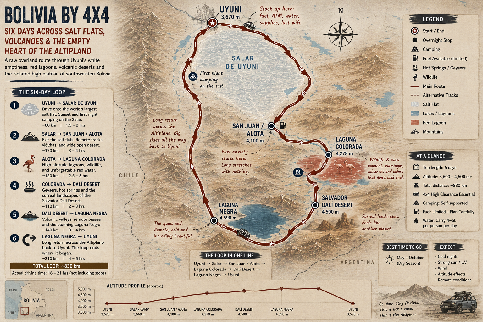
That route immediately felt different, not because it sounded luxurious, but because it sounded isolated.
There were stretches where fuel planning mattered, offline maps mattered, and wrong turns could become very inconvenient very quickly. The remoteness became part of the appeal.
At the same time, we also realized Bolivia is not the ideal place for complete overconfidence.
The distances are enormous. Altitude affects judgment more than people admit online. Road conditions change constantly. And mobile signal disappears for long sections once you leave Uyuni behind.
Initially we debated organizing everything independently.
In theory it sounded simple: rent vehicles, download maps, buy supplies, figure things out ourselves.
The reality turned out more complicated.
Finding reliable information about fuel stops, road conditions, seasonal accessibility, camping permissions, and recovery support if vehicles broke down was surprisingly difficult.
In the end, we used a smaller local agency in Uyuni for vehicle preparation, basic route support, satellite communication backup, and local navigation advice. That ended up being one of the smartest decisions of the entire trip.
The journey still felt raw and unscripted, but we avoided turning avoidable mistakes into genuinely dangerous situations.
The Altitude Problem Nobody Properly Explains
Before Bolivia, altitude was something most of us associated with hiking.
Bolivia changes that immediately.
Uyuni itself already sits around 3,600 meters. Large sections of the route climb significantly higher.
The strange thing about altitude is that it does not always hit dramatically.
Sometimes it feels subtle: poor sleep, headaches, dehydration, shortness of breath, random fatigue, or your heart rate suddenly behaving like you just sprinted uphill despite standing still.
The first sign that we may have underestimated things came at the airport in La Paz before even reaching Uyuni. One of us walked upstairs carrying luggage and genuinely needed a recovery break halfway.
Another laughed so hard at that sight that he triggered his own coughing fit from lack of oxygen.
That basically set the tone for the rest of the trip.
By the time we reached Uyuni, coca tea had quietly become part of daily survival. So had constantly drinking water and pretending everybody felt more acclimatized than they actually were.
One friend confidently announced on Day 2 that altitude “didn’t really affect him.” An hour later he became visibly winded trying to move camping gear thirty meters across the salt flats.
Bolivia humbles people very efficiently.
Nobody Packed Properly for the Temperature Swings
One thing Bolivia does extremely well is destroy your assumptions about weather.
The problem is not simply that it gets cold. It is that the temperature changes feel completely disconnected from each other depending on altitude, sunlight, wind, and time of day.
Mornings often started below freezing. By midday, direct sun suddenly felt brutally hot. Then after sunset the temperature collapsed again almost immediately.
By Day 2, the inside of both vehicles looked like mobile clothing explosions.
Everybody was constantly adding or removing layers: jackets, beanies, windbreakers, gloves, thermal layers, sunglasses, buffs, and sun hoodies.
One friend made the classic mistake of assuming “desert equals hot.” He packed mostly lightweight clothing and spent half the trip borrowing outer layers from everybody else once the temperature dropped after dark.
The altitude sun also turned out to be far more aggressive than expected.
Several of us became badly sunburned despite cool temperatures simply because UV exposure at that elevation is intense, especially reflected off the salt flats for hours at a time.
Sunglasses stopped feeling optional very quickly on the Salar. So did lip balm and sunscreen.
Dust created a different problem entirely.
Fine powder somehow found its way into bags, camera gear, jackets, shoes, sleeping gear, and occasionally food.
By the final days, everybody’s clothing carried the same permanent layer of desert dust no matter how often we tried cleaning things.
Eventually nobody cared anymore.
Food, Water and the Constant Fuel Anxiety
One thing we completely underestimated before Bolivia was how quickly ordinary logistics start dominating conversations once you leave Uyuni behind.
Back home, food is background noise during road trips. In southwestern Bolivia, it becomes planning.
Outside larger settlements, there are long stretches where you should not assume restaurants, fuel stations, mobile signal, or even reliable drinking water will appear exactly when expected.
That changed the atmosphere inside the vehicles surprisingly quickly.
Before leaving Uyuni, we ended up buying far more supplies than originally planned: large water containers, instant coffee, bread, fruit, electrolyte tablets, ramen, cookies, nuts, protein bars, trail mix, jerky, chocolate, and emergency backup food that everybody initially mocked until the first genuinely long driving day arrived.
After that, nobody questioned the snack strategy again.
By Day 3, the vehicles had basically turned into moving convenience stores.
At altitude, people burn energy strangely fast even without intense physical activity, and long hours of driving through dry cold wind somehow leave everyone permanently hungry and slightly dehydrated at the same time.
Energy bars ended up mattering far more than expected simply because proper meal stops were not always predictable. Sometimes lunch happened normally. Other days somebody would suddenly realize it was already 4 PM and the group had been surviving entirely on coffee, snacks, and denial.
Water mattered most.
The combination of altitude, dry air, sun exposure, and constant wind dehydrates people incredibly fast in the Altiplano, often before they fully realize it is happening. Most days, each vehicle carried multiple large reserve containers in addition to individual bottles because several sections of the route simply do not have dependable resupply points.
Fuel created a different kind of stress.
In cities, nobody thinks emotionally about fuel gauges. In southwestern Bolivia, everybody suddenly watches them constantly.
Several locals warned us early not to assume fuel availability would always be straightforward outside major towns. Some stations operate irregularly, fuel deliveries can be delayed, and long detours are not uncommon depending on road conditions.
From that moment onward, fuel stops became psychologically important events.
At least once per day somebody asked: “How far exactly is the next station?” Nobody ever sounded fully reassured by the answers.
Food itself became simpler the further south we travelled.
In Uyuni and larger stops, meals were easy enough: soups, rice, grilled meat, fried chicken, bread, pasta, and surprisingly decent coffee in some places.
But deeper into the Altiplano, expectations needed adjustment.
Several nights involved extremely basic roadside meals or cooking directly beside the vehicles while wind tried aggressively to interfere with everything.
Oddly enough, those meals became some of the most memorable parts of the trip.
At altitude, after full days of dust, driving, and cold wind, even instant noodles and hot soup start feeling emotionally significant.
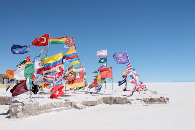
Leaving Uyuni Behind
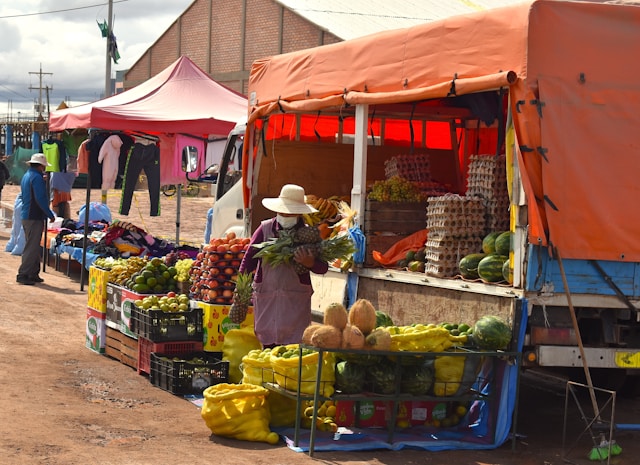
Uyuni itself is rough around the edges in a way that immediately feels real.
Dusty streets, 4x4 repair shops, tour agencies, hostels, dogs sleeping beside parked vehicles, and tourists wandering around buying snacks and oxygen tablets before disappearing south into the desert.
Everybody there is chasing roughly the same thing: the Salar.
The atmosphere inside our vehicles still felt slightly overexcited when we finally left town.
Initially everybody behaved like tourists: taking photographs constantly, arguing about playlists, stopping every twenty minutes, and pretending we fully understood remote desert navigation because we had downloaded offline maps the previous evening over unreliable Wi-Fi.
That confidence faded remarkably fast.
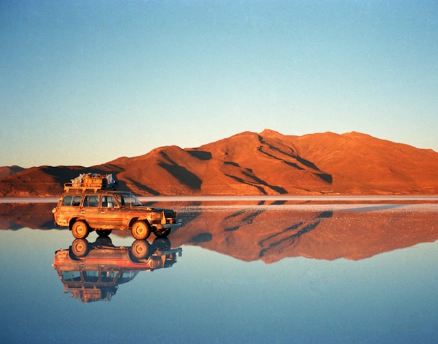
Once you actually drive out onto the Salar de Uyuni itself, the world becomes almost unnervingly empty.
There are moments where the horizon disappears so completely that the vehicles feel stationary even while moving. The white surface reflects sunlight so aggressively that depth perception starts behaving strangely after several hours.
And then there is the silence.
Not peaceful silence.
Massive silence.
The kind where switching off the engine makes everybody instinctively lower their voices without understanding why.
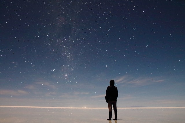
Camping on the Salar
That first night camping directly on the salt flats changed the emotional scale of the trip immediately.
By sunset, the tourist vehicles had mostly disappeared back toward Uyuni and suddenly it felt as if the five of us had somehow been left behind on another planet.
The temperature dropped unbelievably fast after dark.
One minute everybody sat outside drinking beer and talking nonsense while the sunset turned the Salar pink and orange. Forty minutes later people were aggressively layering jackets and accusing each other of underestimating desert cold despite all of us having done exactly that.
The stars that night genuinely did not look real.
At 3,600 meters with almost no light pollution anywhere, the sky became overwhelming. The Milky Way looked bright enough to cast shadows across sections of the salt crust.
One friend tried setting up a camera timelapse and accidentally locked himself outside his own tent while wearing only thermals and sandals. Another spent nearly half an hour insisting he could hear “movement” outside camp before eventually realizing it was just wind vibrating loose cookware attached to the roof rack.
That became the rhythm of the trip: equal parts awe and incompetence.
The Long Drive South
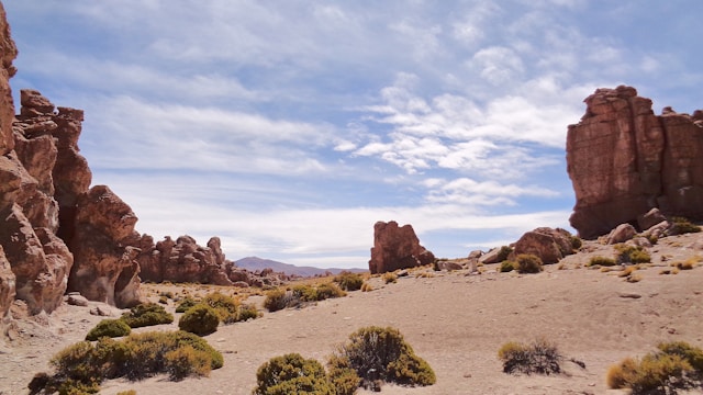
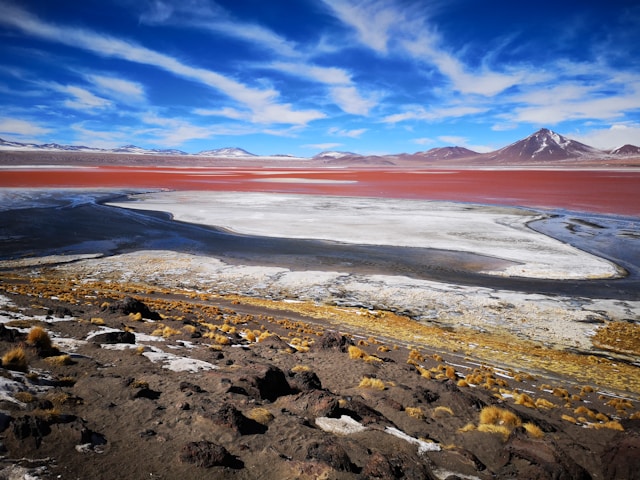
As the route pushed further south toward Laguna Colorada and the Eduardo Avaroa region, the landscapes somehow became even stranger.
There were stretches where the terrain looked unfinished.
Red lakes full of flamingos. Steam vents erupting beside the road. Mountains in impossible colors. Rock formations that genuinely looked artificial.
The driving was far more tiring than we expected too.
People imagine overlanding as relaxed scenic cruising. Bolivia corrected that idea quickly.
Road conditions constantly changed: deep sand, corrugation, rock, soft salt, mud near lagoons, and stretches where the “road” seemed to exist only because enough previous vehicles had vaguely agreed upon a direction.
By Day 4, everybody had developed strong opinions about each other’s driving.
One friend drove aggressively like every section was Dakar Rally qualifying. Another braked for absolutely everything including shadows and harmless-looking rocks. At least twice per day somebody shouted: “WATCH THE EDGE.” Nobody ever fully explained what edge they meant.
The vehicles themselves gradually became tiny mobile ecosystems after several days: dust everywhere, water bottles rolling beneath seats, camera gear, sunscreen, headache tablets, half-eaten snacks, coca leaves, and permanently tangled charging cables.
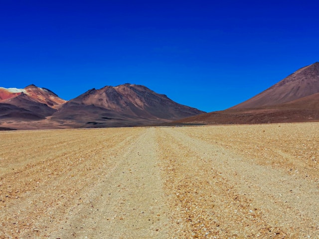
The Desert Starts Feeling Unreal
The Salvador Dalí Desert especially felt deeply unsettling in person because nothing there seemed proportioned correctly.
Massive isolated rock formations sat scattered across completely empty plains beneath violent blue skies while distant volcanoes floated across the horizon.
At one point we stopped the vehicles simply because everybody needed silence for a few minutes.
Not for photographs. Not for hiking.
Just because the place itself felt mentally overwhelming after enough hours inside it.
The remoteness also affected the group psychologically in ways none of us expected.
There were places where you could stand outside the vehicles, turn slowly in a complete circle, and see absolutely no signs of human infrastructure anywhere: no buildings, no power lines, no roads, no movement.
Just wind and volcanic desert stretching endlessly toward the horizon.
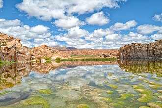
Laguna Negra
Unlike the more photographed sections of Bolivia’s southwest, Laguna Negra felt hidden and strangely private.
The lake itself sat dark beneath massive volcanic rock walls while almost no other travelers appeared anywhere nearby.
That evening became one of the quietest of the entire trip.
Nobody drank much. Nobody argued about music. Even the usual sarcasm level inside the group dropped noticeably.
Everybody just seemed tired in a satisfied kind of way.
The strange thing about long overland trips with close friends is that eventually everybody stops performing normal versions of themselves. The exhaustion, altitude, dust, cold mornings, navigation stress, and constant proximity slowly strip conversations down into something simpler and more honest.
You stop talking about work almost entirely.
Life narrows into immediate practical concerns: fuel, weather, water, distance, sleep, road conditions, light, and whether the vehicles are making unfamiliar noises.
And somehow that shrinking of the world becomes oddly calming.
Returning to Uyuni
By the drive back toward Uyuni, the group dynamic had completely flattened out.
Nobody cared anymore who chose the music, who drove longer shifts, or whose original planning ideas had been terrible.
We were all equally dusty, sunburned, slightly dehydrated, and fully invested in squeezing every last hour out of the trip before returning to normal life.
Back in Uyuni, actual buildings and paved roads felt almost suspiciously civilized after nearly a week out in the Altiplano.
That final evening, we sat around replaying the trip through increasingly exaggerated storytelling: minor navigation mistakes became survival scenarios, ordinary potholes became canyon-sized obstacles, and one completely harmless desert fox somehow evolved into “the wild animal encounter.”
But underneath all the exaggeration was something real.
Bolivia had done exactly what we secretly hoped it would do.
It had broken routine completely.
For six days, the five of us disappeared into landscapes so strange and oversized that normal life genuinely stopped feeling relevant for a while.
FAQ
Is a 4x4 route better than biking for this part of Bolivia?
For this specific six-day loop, 4x4 made it easier to cover major landscape shifts safely while still keeping a raw overland feel.
How difficult is altitude on the Uyuni and Altiplano route?
Altitude affects most people more than expected. Hydration, slower pacing, and conservative daily plans matter as much as route planning.
Do you need a local agency if you already have offline maps?
Offline maps help, but local support for vehicle prep, seasonal route conditions, and backup communication can reduce risk significantly.
Is six days enough for Salar de Uyuni and deeper southwest routes?
Yes, if your itinerary is focused and realistic. Six days gives enough range for Salar camping plus remote desert sections without turning every day into a race.
What matters most: food planning or fuel planning?
Both matter, but fuel planning is usually the higher-stakes variable. Water and food reserves should still be treated as non-negotiable.
Want to turn this into your own editable trip plan?
Start with this Bolivia overland structure in Honge, adjust pacing and stops, and turn the narrative into a practical route with logistics you can actually execute.
Related itineraries
About The Author
Honge is a travel planning platform focused on practical, experience-led itineraries. Our editorial travel stories combine first-person route context, local friction, and planning realism so readers can convert inspiration into workable plans. We prioritize grounded detail over checklist-style travel content.
Image credits: Photos are sourced from Wikimedia Commons and Unsplash. Copyright remains with the respective photographers and rights holders. Images from Wikimedia Commons are used in accordance with their applicable licensing terms, including the Creative Commons Attribution-Share Alike 4.0 International license where noted. Unsplash images are used in accordance with the Unsplash License.
Travel disclaimer
This itinerary is intended as general travel inspiration and planning guidance only — not as personalised travel advice. Conditions change. Before you travel, check the current entry requirements, visa rules, and any travel advisories issued by your government for your destination. Review weather forecasts for your specific travel dates, confirm opening hours and ticket availability for attractions directly, and take out comprehensive travel insurance that covers medical, cancellation, and disruption. Honge is not responsible for any changes to conditions, services, or experiences described in this article after the date of publication.